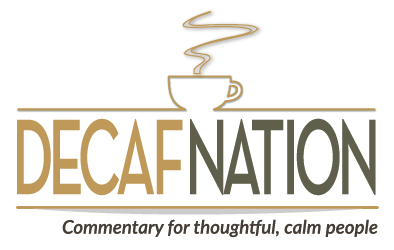

PHOTO: 21st Street is in the middle at the bottom, with the car lot on the right side. It crosses Cliffe Avenue and dead-ends at the Courtenay Airpark boundary. Dave Bazett photo
A proposed new bridge would kill the Courtenay Airpark, walkway, Hollyhock Marsh, undermine Kus-kus-sum and add another signal light on Comox Road. So why is the City of Courtenay promoting it? Even mayoralty candidates aren’t sure
The City of Courtenay has floated a proposal to build a third crossing of the Courtenay River at 21st Street to alleviate traffic congestion at the 17th Street and Fifth Street bridges.
The proposal, which is part of a study for the city’s required update of their 2014 Master Transportation Plan, would wipe out the Courtenay Airpark, part of the Airpark walkway, destroy the estuary’s last remaining intact ecosystem at Hollyhock Marsh, undermine the Kus-kus-sum rehabilitation project and create another major signaled intersection on Comox Road at a point that regularly floods during winter storms.
Not to mention that Hollyhock Marsh is protected crown land and is an area under claim by the K’omoks First Nation.
It’s an idea that has left many people shaking their heads.
“I thought it was an April Fools Day joke,” said Dave Bazett, a land surveyor whose office is in the proposal’s path and who owns two aircraft hangared at the airpark.
Project Watershed Technical Director Dan Bowen said the study appears to have been done by someone who doesn’t know anything about the area.
“And, who employs someone to pursue an idea that’s not feasible?” he said.
Bazett pointed his finger at the city, which defined the scope of the transportation plan update for the consultant, including a bridge south of 17th Street and the idea that the airpark and the marsh were expendable.
Even the three announced candidates for Courtenay mayor tried to distance themselves from the proposal.
David Frisch emphasized that the proposal is not a plan, just some consultant’s idea. He said there are more environmentally friendly options.
Bob Wells said he didn’t know how a third crossing got in the plan. He thinks its an option the consultant picked up from previous studies, before Kus-kus-sum became a community project.
Erik Eriksson wondered how many millions of dollars per minute of wait time at the existing bridge intersections the public is willing to pay for. A new crossing would cost tens of millions of dollars.
“So we’re not going to see another bridge in my lifetime,” Eriksson said.
Background
The city has undertaken a required four-year update to its 2014 Master Transportation Plan. It held an open house in March and another in mid-June, and is conducting an online survey.
The study and community feedback will be presented to the Courtenay City Council over the summer. Council members will decide what parts of the study get costed out and eventually make it into the 2018 Master Transportation Plan.
Take the survey here
FURTHER READING: See the study’s open house display boards; The city’s Master Transportation Plan webpage
The 2014 plan also examined options for a third crossing. It rejected crossings at 19th and 26th streets, and suggested Eighth or 11th streets for new bridges. The city eventually costed out an 11th Street bridge at around $35 million, and later dropped the idea.
But traffic congestion at the 17th Street east intersection and at the Fifth Street east intersection has worsened as the Comox Valley has grown. But is it unbearable?
Wait times at the bridges may pale now in comparison to the Langford Crawl in Victoria or to numerous choke points in Vancouver, but without an acceptable long-term solution, motorists’ frustration will magnify.
Why 21st Street won’t fly
Bowen, a former BC Ministry of Highways employee in the Comox Valley, said the third crossing proposal and other proposals in the study to build new roads across the Courtenay Flats farmland “fly in the face” of everything Project Watershed has been trying to achieve.
“We’ve been working on projects over the past 20 years to preserve and protect the remaining flora and fauna habitat along the river and K’omoks estuary,” he said. “This proposal has no regard for the estuary. It’s single-minded and not well-informed.”
Local citizens fought Crown Zellerbach from filling in the marsh back in the 1960s and battled them and the provincial government to save the pristine ecosystem, which is unique in the Comox Valley.
Hollyhock Marsh is the model for Kus-kus-sum, a project to restore of the old Fields sawmill site, and the marsh is it’s connection back to the estuary.
“It’s a non-starter for us (Project Watershed,” Bowen said. “And I would expect for K’omoks First Nation, too.”
Decafnation was unable to reach K’omoks Chief Nicole Rempel for this story.
Bazett, a pilot who uses aircrafts in his land surveying business, considers the 21st Street crossing a “purposeful attack” on the Courtenay Airpark.
Bazett says the city has tried to shut down the airport before and neither the mayor or council members have been supportive.
“This crossing was concocted as an excuse to eliminate the airpark,” he said. “The study didn’t even consider air transportation.”
He doesn’t think the city realizes the economic impact and importance of the airport. It brings pilots and passengers to town and the RCMP and MediVac helicopters use the facility regularly.
“It’s a precious jewel,” he said. “There are few private airparks in the province for both float and land aircraft, and within walking distance of town.”
Better options
Bowen said his experience working with the highways ministry taught him there are better options to improve traffic flow.
The primary problem is that there are two northbound lanes of traffic approaching the bridge from the south on Cliffe Avenue and two lanes on the bridge. But whether you turn north or south, you have to merge down to one lane.
It’s the same approaching the bridge from the north on the Island Highway bypass, which is two lanes at Superstore, but merges down to one lane at the bridge.
Bowen believes there should be four lanes of traffic approaching the 17th Street bridge, across the bridge and then all the way to the Shell gas station at the old Island Highway and also part way toward Comox.
The long-term solution, he said, is to twin the 17th Street bridge. The highways ministry purchased extra land on the north side of 17th Street east of Cliffe Avenue to anticipate a widened bridge. That land looks like a park with cherry trees.
The ministry also designed the bypass for four lanes, which is why the shoulders are extra wide through the S-turns.
Bowen agree with Erik Eriksson about also widening the Fifth Street bridge and making it four lanes from the Shell gas station at the bottom of Mission Hill all the way to Cliffe Avenue.
An election issue?
City Councillor Eriksson says the study is flawed in another important way: it only considers Courtenay boundaries.
“Any traffic study has to be regional,” he said. “And Comox people should help pay for any traffic improvements.”
Councillor Frisch wouldn’t rule out a third crossing forever, but he said “city taxpayers are not going to pay $20 million to $30 million for a new bridge.”
The question for him is where to spend the city’s limited funds.
“If we spend it on a bridge now, what’s the lost opportunity to support walkability, cycling, transit and other things,” he said.
City Council candidate Melanie McCollum said the cost of building a bridge across a estuary seems potentially prohibitively high.
“It’s very sensitive habitat. It would also mean building into sediment, which liquefies in an earthquake,” she said. “Of course this is not my area of specialty, but from what I know, building a bridge in an earthquake zone on sediment will incur some very expensive geoengineering.”
McCollum would also like to know if the plan for this bridge had taken into account sea level rise expected in the next 50 to 70 years.
Courtenay Mayor Larry Jangula did not respond to our questions.
Why do we need another bridge when Vancouver only has 3 and they have a much higher population and density. Improve public transit which is pathetic despite enormous efforts by some to improve it due to lack of will.
I went to the Master Transportation Plan open house. The plan included nothing about actually reducing vehicular traffic on our roads. To me, that’s an unbelievably short-sighted view. Bus service in the Valley is terrible. Many, many people would take public transportation if it ran often and everywhere. It seems bus service and planning for roads were completely separate from each other, which is ridiculous. I oppose building a third bridge, most especially if it’s going to impact Hollyhock Marsh and Kus-Kus-Sum. The City of Courtenay has bought into the Kus-Kus-Sum project, so why on earth would they now be talking about a bridge there? It makes no sense whatsoever.
I agree Megan, and let me add one more consideration: urban area zoning, transit routes and transportation plans must be done in concert. Considering one without the others only causes more congestion and chaos down the road.
Great points!
We need to demand more clarity of intention and purpose from our planners! Transit situation is something that probably needs restructuring?
Courtenay/Comox is 1 % of the BC population and transportation needs are minor compared to Vancouver /Victoria, therefore it will take considerable political influence in order to obtain multi millions for major improvements here. Two additional lanes on 17th St. Bridge with east end extending across Farquarson Farm to MacDonald, 4lanes to Lerwick/Guthrie for major dispersement of East Courtenay/Comox traffic would be the cheapest, easiest and most direct way to relieve current and anticipated future traffic growth. Yes, Farquarson is prime ALR , currently used primarily for bird food, but a single road through (eg. Delta Ring Road), would have minimum impact both here and other Courtenay River and Estuary areas.
Harry — Expanding and improving traffic flow on the existing bridge makes the most sense to me, too. There could be a free-flowing right lane that allows people coming from the south on Cliffe to cross the bridge and onto Comox Road without a signal.
Great idea to maximizewhat already exists. Through design and education.
We just spent about last year bridging the Puntlage and the Airpark Lagoon. It has been paying off big time with the vast numbers of youg salmon surfacing in the lagoon and now they want to do away with the airpark and I have heard the rumour that someone on the city council (no names) suggested that the Airpark would be better suited for dozens of condos. Think of the tax income with services not far away. High density in such a prime spot. Think of the jobs at the airpark now 2 flight schools and now one is training Airforce Cadets, Harbour Air has been making inquiries of having some more of their aircraft maintained at the Courtenay Airport as they are now doing some but would like to move more maintenance to Courtenay because of the cost of lease, taxes and land at the Vancouver Airport. Langley or Pit Meadows only has the Fraser river to land in and is only clear part of the year and not like here for their float planes,
Please mind the spelling and grammar …….sorry written in a hurry.
Appreciated hearing your excellent points re: jobs and salmon!
Wow, isn’t that great to learn that the Courtenay Air Park is ‘on the map’. And wonderful to know that the salmon runs are coming back.
The bridge to nowhere. Where will it lead the cars and traffic? It makes no sense and really does not deserve much discussion.
I would like to talk about our already third crossing. It has just been completed and is over the Tsolum and leads cars up Memorial Way to the hospital the East End of Courtenay, the Little River Ferry, the Airport and Costco. It bypasses completely the 17th St. Bridge and the city of Courtenay if you are coming from the South on the freeway.
I drive Wheels for Wellness which is a non-profit organization that transports sick and elderly people South to the Nanaimo and Victoria hospitals. When I return and I hit the first turn off #117 into Courtenay I am greeted with large highway signs that direct me to the hospital, airport, ferry and the police through the main part of town and over the 17th. St. bridge.
If I take the 2nd entrance #128 I can get to the East End of Courtenay and the hospital in 15 minutes with meeting only four stop lights. If I take the recommended way at the 117 exit I am faced with 11 lights to get to the hospital and who knows how much time getting over the 17th St. bridge. We need those signs changed to direct traffic to the North entrance.
Finally, let’s get some cameras up so those people planning to get to the West side of Courtenay can check the bridge traffic and plan their day better. There are many ways we can alleviated traffic and road blocks without building a $500,000,000 bridge to nowhere to save 10 minutes of waiting.
Jim Gillis
Jim — You make an excellent point about the signage, and the choice of exits to reach different parts of our community. Thanks!
Very illuminating reply, Jim!
The signage is so important to get right and in more than one place to allow for planning! The cameras are a smart plan for any sometimes difficult areas.
Thank you.
Frances